 |
An Overview of Tools for Integrating
Environment Management and Disaster Risk Reduction
| |
|
 |
Hari Srinivas |
|
Management Tools Series E-101. April 2015.
|
I. INTRODUCTION
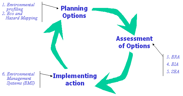
This document provides a brief introduction to tools that assist in understanding the cyclical interlinkages between environmental management and disaster risk reduction. Each of the tools provide different methodologies and results, and enable different decisions to be taken. The six tools are divided into three parts:
- to develop planning options (Environmental Profiling and Eco and Hazard Mapping)
- to assess the options (Environmental Risk Assessment, Environmental Impact Assessment, and Strategic Environmental Assessment)
- to implement action (Environmental Management Systems).
These tools are usually applied at the micro/local level, with active participation of not only the local government, but also other takeholders such as NGOs, universities/schools, trade and business entities etc.
While these tools are an adaptation of existing environmental management tools applied to integrating environment and disaster risk reduction, many other tools also exisit, developed by specific organizations and institutions. Examples include UNEP's APELL and UNOCHA's FEAT (See the Tools section for more information). Geographical Information Systems (GIS) have not been included here since they are too numerous for the purpose.
II. THE E+D TOOLBOX
| |
Planning Options |
1 |
Environmental Profiling |
Creating an environmental profile (EP) of an area or community is a first and critical step in understanding the interactions between the local environment and disaster vulnerabilities it faces.
 |
An 'environmental profile' (EP) provides a systematic overview of the development, environment and disaster setting, and institutional arrangements of an urban area, which is designed to highlight the environment-disaster interactions, the critical issues, and the sectors and stakeholders directly concerned with them.
In this tool, a brief introduction to the social, economic and physical features of the city is made. The city's various sectors, their characteristics, use of environmental resources and impact on environmental resources are mentioned under �Development Setting�E In �Environmental Setting�Emore details of the natural and built environments are provided, while risks related to the vulnerabilities and hazards faced by the city�s communities are mentioned in the �Disaster Setting�E The last section contains actual planning and management options for disaster preparedness. |
| |
Planning Options |
2 |
Eco and Hazard Mapping |
Eco and Hazard Mapping (EHM) is a visual tool that creates an inventory of environmental assets of an area or community, and the vulnerabilities and risks it faces.
 |
Eco and Hazard Mapping (EHM) is a systematic but simple method of conducting an on-site environmental review by collecting information which shows the current situation using pictures and maps. It covers a range of issues, including information on the current situation, problems areas, water, sewage, soil, air, energy, waste, etc. It also includes geo-hydrological risks and hazards faced by the urban area.
EHM has been an effective, systematic means of inventorying environmental practices and problems, communicating environmental issues to urban residents, engaging them in environmental practices, and implementing action at the local level.
EHM is a very visual tool that uses plans and maps of buildings and neighbourhoods to identify and mark the environmental aspects of the urban setting, and the potential hazards and risks that they pose. Due to the simplicity of this inventory process, multi-stakeholder participation is easily enabled. It also facilitates post-disaster recovery and reconstruction by providing a baseline against which plans can be developed. |
| |
Assessment of Options |
3 |
Environmental Risk Assessment |
Environmental Risk Assessment is a systematic analysis of the likelihood that the environment will experience a specified level of harm as a result of a natural disaster or a planned human activity.
 |
All decisions and actions have environmental consequences and risks. Risk is the likelihood that a harmful consequence will occur as a result of an action , including those from natural or man-made disasters. ERA determines the potential impact of an action on ecosystems, habitats and other ecological resources, and on human health and well being.
It includes both risk management and risk communication. The use of ERA in environmental planning and management is fast becoming a standard practice, either as a stand alone procedure or as a support or complement to an EIA. Appropriate use of ERA will identify situations of potential environmental concern and allow decision makers to select management options with the least, and still acceptable level of risk.
ERA is a well developed and systematic tool that provides the necessary information to take decisions that will mitigate and reduce the risks faced by vulnerable communities �Ewhether from man-made aspects (such as chemical accidents or development projects) or natural aspects (such as earthquakes and tyhpoons). It calls for the clear identification and formulation of the problem and characterize the risks posed as a result. It calls for the instituting of a risk management plan that is periodically reviewed, and the results and decision properly consulted and communicated to all key stakeholders. |
| |
Assessment of Options |
4 |
Environmental Impact Assessment |
Environmental Impact Assessment is a formal process used to predict the environmental consequences of a project or an event. EIA ensures that the potential problems are foreseen and addressed at an early stage.
 |
Environmental Impact Assessment (EIA) is a structured procedure designed to help ensure that projects and programmes are environmentally sound and sustainable. Adopted to disaster situations, EIA facilitates identification, analysis and evaluation of potential environmental impacts and the identification and elaboration of measures that will avoid, remedy or mitigate any adverse impacts from these disasters, whether man-made or natural.
It allows informed decision making on the action to be taken, and establishes a monitoring and environmental management regime for implementing mitigation measures, monitoring impacts for compliance and ascertaining if impacts are as predicted.
The EIA tool, well known for the assessment of development projects such as a dam or a complex of factory buildings, can also be used for disaster planning and management. Like the ERA tool, it enables informed decision making on the development of a city, but also in preparing for disasters (whether natural or man-made), and in monitoring and evaluation of the action taken. |
| |
Assessment of Options |
5 |
Strategic Environmental Assessment |
Strategic Environmental Assessment (SEA) is a process to ensure that significant environmental effects arising from disasters are identified, assessed, mitigated, communicated to decision-makers, monitored and that public involvement is ensured.
 |
Strategic Environmental Assessment is a systematic process for evaluating the environmental consequences of policies, plans, programmes or proposals, to ensure that they are addressed early in the decision making process and on par with economic and social considerations . Applied to disaster management, it also helps in understanding the environmental consequences of pre- and post-disaster activities.
Undertaking SEAs can also contribute to sustainable development goals, promote accountability and credibility among the general public and specific stakeholders, and lead to broader policy coherence.
For simplicity, SEA can be broken down into different activities conducted alongside the development of disaster mitigation plans or programmes, and consideration of alternative options.
- Stage A: Local authorities needs to consider the availability of background information and propose objectives and indicators for the SEA. This material is required at the outset when issues and options are being developed
- Stage B: Local authorities decide the likely scope of the environmental report, and what level of detail to be examined. Other stakeholders are consulted in this process. At this stage, reasonable alternatives to the plan are identified
- Stage C: Local authorities assess the likely effects on the environment of the evolving plan, and its alternatives. Where there are significant adverse effects as a result of the plan, information needs to be provided on how these will be reduced, prevented or offset
- Stage D: The report is a key output to the SEA and should be available for consultation. After consultation responses have been received, a statement is made regarding how the responses were taken into account in the evolving plan
- Stage E: Monitoring of the significant environmental effects of implementing the plan. This allows any unforeseen adverse effects of the plan to be recognised and dealt with. Monitoring also enables future predictions to be made more accurately and provides baseline information for future plans.
|
| |
Implementing Action |
6 |
Environmental Management Systems |
Environmental Management Systems is a problem-identification and problem-solving tool, based on the concept of continual improvement, that can be implemented in an area or community in many different ways
 |
An Environmental Management Systems (EMS) is a systematic way to ensure environmental issues are managed consistently and systematically. Effectively applied, an EMS can help integrate environmental considerations within a larger disaster management plan. Developing an EMS lies at the core of the international environmental standard, ISO 14001.
It sets out environmental policies, objectives and targets for the implementing organization, with pre-determined indicators that provide measurable goals, and a means of determining if the performance level has been reached. Often these are the same performance indicators that are chosen for strategic reasons.
An EMS follows a Plan-Do-Check-Act Cycle, or PDCA. It first develops an environmental policy, plans the EMS, and then implements it. The process also includes checking the system and acting on it. The process is continuous because an EMS is a process of continual improvement where it is constantly reviewed and revised. |
III. CONCLUSION
Integrating environment and disaster dimensions in local planning processes is a complex mix of consultation, dialogue and monitoring involving all critical stakeholders, particularly the vulnerable communities.
Much needs to be done when planning for environment and disasters. Due to its complexity and wide scope, a multi-stakeholder partnership that plans, implements and reviews programmes is absolutely important.
A number of issues need to be considered when interlinking and integrating disaster and environment aspects in post-disaster planning as well:
- Appropriate environment management and quick restoration is also crucial in the wake of disasters
- Proper waste management: clearing, sorting, recycling/reuse, disposal of disaster debris
- Assessing water contamination and pollution, for drinking and for other purposes
- Appropriate handling of hazardous and toxic materials
- Rapid environmental assessments of the environmental damage
For all the tools introduced above, there are some common, cross-cutting tasks that need to be taken, including:
- Identifying the key stakeholders and establishing their roles, resources, and concerns.
- Evaluating the hazards and risks that may result in emergency situations in the community.
- Having stakeholders review their own plans to ensure a coordinated response, and identify lacks and gaps.
- Matching these tasks to the resources of the identified participants.
- Identifying resources needed, making necessary changes to improve plans, and integrating them into an overall community plan.
- Getting political commitment from local and national governments.
- Educating and training participating groups about the integrated plan, including emergency responders.
- Establishing procedures for periodic testing, review, and updating of the plan.
The four overal aims that drive the above tasks are outlined below:
- 1. Build local community capacity
-
It is important to support and build
local capacities for people to mitigate
and prevent disasters, and cope
with post-disaster impacts, including those that have environmental precedencies.
Such capacities will also enable
communities to cope better with those
few disasters which are unavoidable.
- 2. Create partnerships & alliances
-
There are a number of organizations
and groups that are involved,
or need to be involved, in
environmental management and disaster risk reduction. It is important
to build participatory alliances
and partnerships among these
entities in order to map out
responsibilities and activities.
- 3. Share and exchange information
-
Knowledge embedded in different
organizations and groups need to be
recorded and shared among all of them,
and used for different purposes. Regular
learning opportunities are critical for
communities to understand,
experience and prepare themselves
for a disaster.
- 4. Develop learning and decision-making tools
-
Existing knowledge and understanding
of disasters, man-made and natural
has to be used to develop learning
and decision-making tools that can be
used for disaster mitigation, including
the creation of disaster maps, mitigation
plans etc.
Ultimately, a multi-stakeholder knowledge sharing mechanism at the local level goes a long way in ensuring that all aspects of the local environment are considered in disaster mitigation and preparedness plans. A number of issues need to be considered to develop such a mechanism:
- Help find appropriate and sustainable solutions, by generating a helpdesk function for technologies, methodologies and good practices
- Record and provide critical experiences and lessons learnt in past disasters, by building a forum for exchange of such information
- Inventorize institutional and individual knowledge gained from responding to the tsunami disaster by developing a database of strategies, policies, programmes and projects being undertaken.
- Capacitate local communities to prepare them for the next disaster, by producing and collating training materials and courses
- Channel scarce funds to appropriate and critical areas that need them, by networking with communities and organizations to enable matching offers and requests.
Post-disaster situations are equally important in integrating and interlinking environmental aspects with disaster management. Besides assessing the damage from the disaster on the local environment (on water, land, air, man-made buildings and infrastructure, their restoration and proper handling of wastes and hazardous/.toxic materials are also important.
REFERENCES:
- UN HABITAT, "Preparing an Environmental Profile". The Sustainable Cities Programme, United Nations Human Settlements Programmes (UN-HABITAT), 1998
- UNEP, "Environmental Risk Assessment: A Practitioner's Guide" United Nations Environment Programme, 2003.
|
| |
Do you have any suggestions or additions to make on the above information? Please send an email to Hari Srinivas at [email protected]
|
|
