 |
Hari Srinivas |
|
Case Study Series E-023. June 2015 [Updated February 2021]
|
At 0058 GMT on 26 December 2004, a massive earthquake of magnitude 9.0 struck the coastal area off northern Sumatra in Indonesia. A number of aftershocks also occurred, some of magnitude 7.1. These earthquakes triggered tsunamis that affected Indonesia and neighbouring countries in Asia (including India, Malaysia, Maldives, Sri Lanka, and Thailand) and the coasts of Africa and Middle East (including Somalia and Yemen), causing serious damage to the coastal areas and small islands.
While the final death toll will never be known, an estimated 250,000 persons have perished in the tsunami, majority of them women and children. Millions more were displaced or rendered homeless . The damage from the tsunami was particularly severe as a large percentage of the population, and many key cities and towns, were located within 10 km of the ocean edge.
The international response mounted to provide rescue and relief to the affected communities was unprecedented in its volume and scale, with national institutions, UN and international organizations, community groups and NGOs, and a variety of other entities coming together to provide different kinds of aid and services, in the short and long term.
With the initial focus of the international relief and recovery efforts being on humanitarian aspects of the disasters, attention slowly shifted to longer-term rehabilitation and reconstruction, where environmental issues came to the fore. Recovery of environmental assets, such as water, land, forests and agricultural and fisheries areas, and ecosystems such as mangroves and coral reefs, required a concerted and integrated approach that not only improved these assets, but also made them better prepared for future disasters.
 PART 1:
Observations from the Affected Countries
On the ground assessments and situation reports recorded a number of observations on the impact of the tsunami on the environment in the affected countries. These related to both natural as well as man-made aspects of the environment.
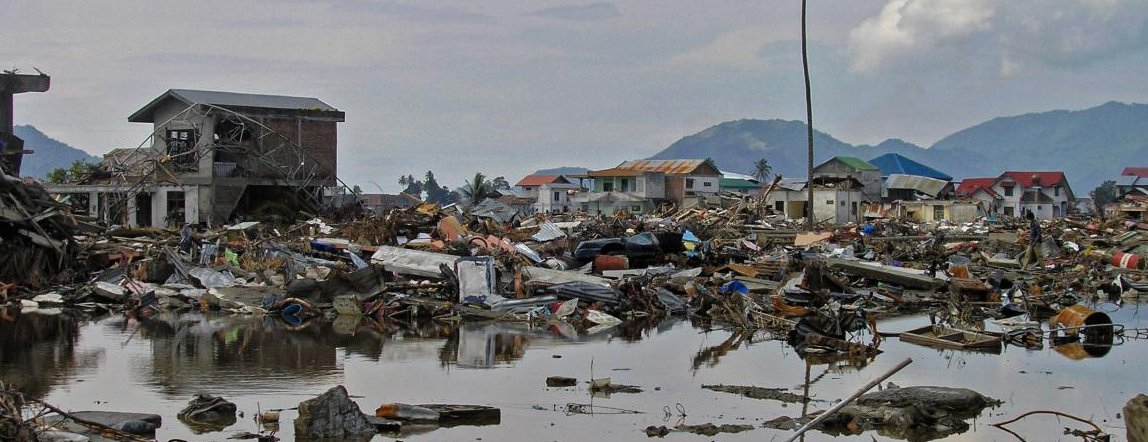
Solid waste and disaster debris remained the most critical environmental problem faced by the countries. The sheer magnitude of the disaster meant that the volume and nature of the disaster debris was far beyond the coping capacities of the cities and towns that were affected. Disposing these wastes in an environmentally appropriate manner, and recycling the waste where possible (for example, crushing of concrete and brick to produce aggregate for road and building construction) were identified as critical priorities.
Combined with the issue of waste was that of hazardous materials and toxic substances that had inadvertently mixed up with ordinary debris. These included asbestos, oil fuel, and other industrial raw materials and chemicals. Rapid clean-up of affected areas has also resulted in inappropriate disposal methods, including air burning and open dumping, leading to secondary impacts on the environment.
Contamination of soil and water was the second key environmental impact of the tsunami. Salination of water bodies such as rivers, wells, inland lakes, and groundwater aquifers has occurred in many of the affected countries. This also affected the soil fertility of agricultural lands, due to salination and debris contamination, which affected yields in the medium and long term. Some water bodies were contamination by damaged or destroyed septic tanks and toilets, with sewage infiltrating the water supply system.
UNEP reported extensive damage to environmental infrastructure, buildings and industrial sites. These included water and sanitation systems, solid waste disposal sites and waste treatment centers, particularly in urban areas (Maldives, Sri Lanka and Indonesia). Oil storage facilities released oil and wastes into the environment, which were not handled properly during the initial clean-up (Maldives and Indonesia).
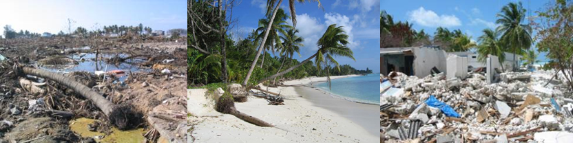
But a number of good environmental practices, which mitigated the damage due to the tsunami, were observed. The 'first line of defense' afforded by healthy well-maintained coral reefs, mangroves, sand dunes and other coastal ecosystems such as peat swamps, provided protection from the tsunami, as evidenced by the damage assessments in Sri Lanka's Yala and Bundala National Parks . A rapid assessment of the environmental impact of the tsunami conducted by the Stockholm Environment Institute showed a similar pattern - sand dunes, mangrove forests and coral reefs helped reduce the energy of tsunami waves in Sri Lanka by acting as natural barriers.
Besides impacts on the environment, the tsunami also demonstrated the need for strengthening the capacities of environmental agencies at the national and local levels to handle disasters and emergencies and their environmental consequences. Besides loosing staff members, and facilities and equipment to the tsunami, the added responsibilities of relief and recovery planning and assessment highlighted the need for comprehensive capacity building in areas such as strategic environmental assessment, integrated environmental management, coastal zone planning etc.
At the local level, the lack of vulnerability and hazard mapping resources, and baseline demographic and other data, compounded the problem of carrying out comprehensive environmental impact assessments. This clearly also affected the installation of community-based early warning systems and long-term disaster management and mitigation plans, as the rehabilitation and reconstruction phases of the tsunami response are implemented. Such information was also felt necessary to assist future monitoring and disaster response strategies .
Indonesia
With the earthquake epicenter less than 40 kilometers from the coast of the Sumatra island, Indonesia was perhaps the worst affected country. The resulting tsunami extensively flooded coastal areas, reaching inland from 500 meters to about two kilometers in the west coast. In some areas along rivers and estuaries, the sea surge extended more than six kilometers inland.
Besides the massive human toll of more than one million killed or displaced, the economic destruction and environmental damage of the Sumatra Island was extensive. Coral reefs, mangroves, coastal areas, wetlands, agricultural fields and forests, aquaculture areas etc. were badly damaged.
Indonesia's BAPPENAs (State Ministry of National Development Planning) damage assessment estimated that 20 percent of sea grass beds, 30 percent of coral reefs, and 25-35 percent of wetlands, and 50 percent of sandy beaches of the west coast, were damaged. The most serious threat to coastal waters was due to the tsunami debris that was dragged into the ocean by the receding waters of the tsunami.
The on-going conversion of mangrove forests into shrimp farms and environmental destruction, were further damaged by the tsunami. Considering the critical function that mangroves play as a filter to the waters that flow from the estuaries to the ocean, their damage due to the tsunami was incalculable - an estimated 90 percent damage was reported to mangroves and coastal forests. Fragile wetlands and estuaries in the affected areas in Indonesia were also affected. Preliminary analysis of satellite images have indicated subsided areas and modified flow of rivers and drainage patterns.
While the more than 70 streams and rivers in the region was expected to be flushed clean over time, the contamination of ground water reservoirs due to saltwater intrusion, sewage, debris and hazardous materials was determined to be much more difficult to remedy. FAO estimates that 30 percent of farmland was affected in the north-east coast, and 70 percent in the west coast - with about 20 percent permanently damaged.
Cities and towns in the coastal area were also extensively damaged, including industrial areas and ports. The debris generated by the tsunami not only mixed different types of wastes (bricks, concrete, wood, vegetation, plastics and metals, etc.), but the backwash carried these wastes and deposited it in the ocean. Existing wastes in landfill sites (particularly those near the coasts in Banda Aceh) were also dredged out into the ocean by the tsunami wave, significantly affecting marine and aquatic ecosystems.
Thailand
Much of the impact of the tsunami on Thailand was along the Andaman coast, affecting six coastal provinces. The impacts on these provinces were varied due to differences in the land forms, slope and elevation, and presence (or absence) of natural barriers such as coral reefs and mangroves.
A number of varied coastal and land ecosystems were affected by the tsunami, particularly coral reefs. About 15 to 20 percent of the coral reefs were affected by the tsunami - due to siltation and sand infiltration. The backwash from the tsunami wave carried debris from inland areas that also damaged the coral reefs. However, deep water coral reefs (beyond three to five meters depth) were not adversely affected.
Sea grass beds in the coastal provinces play a critical role in fishery production, and as a food source. Based on surveys conducted by the Thai government, three to 10 percent of the sea grass beds were damaged, which required about six months to recover from the damage.
Damage to mangrove forests was considerably less than in other countries, with less than one percent of the mangroves affected. In Phang Nga, the most affected province of Thailand, large mangrove forests in the north and south of the province significantly mitigated the impact of the Tsunami. They suffered damage on their seaside fringe, but reduced the tidal wave energy, providing protection to the inland population. Areas where mangroves were converted to shrimp farms, were worse affected during the tsunami.
Inland damage to surface and groundwater resources follow a pattern similar to other affected countries. With land up to three kilometers inland inundated by the tsunami wave, most of the affected water bodies were rendered useless due to seawater/saline infiltration. Water samples analyzed by the Ministry of Natural Resources and Environment from wells dependent on groundwater also showed seawater and debris contamination. Seawater intrusion also affected about 20,000 to 30,000 hectares of land, including vegetation cover, and medium to long-term fertility of the soil.
Damage to infrastructure such as fisheries infrastructure, buildings and bridges, and other structures were extensive, creating not only loss of economic livelihoods, but also extensive debris that had to be cleared in an environmentally friendly manner.
Sri Lanka
The first wave from the tsunami reached the east coasts of Sri Lanka about 100 minutes after the earthquake, with a surge height of 5.5 to 6.5 meters. Over two-thirds of the 12 districts in the north-eastern, eastern and south-eastern coasts were affected - though not uniformly, as a result of the varying land and sea-bed structures.
The pattern of impacts on Sri Lanka's coral reefs, along the southern and eastern coasts, is similar to that of other countries affected by the tsunami. While coral rock mining, blast/purse-seining fishing, and other practices had already impacted a fragile ecosystem, the tsunami exacerbated the destruction, breaking off large sections of the reef, depositing sand and silt on the reefs, including large quantities of waste, soil and organic matter (as a result of the tsunami backwash).
Differing patterns of inundation and damage, seen in neighbouring areas along the Sri Lankan coast, was not related to such coastline features as headlands or river channels, rather, the key factor was the presence or absence of coral and rock reefs offshore . For example, at Hikkaduwa, a hotel is protected by coral reefs that the local communities protect and nurture. Relatively little damage and few deaths were recorded from there to Dodanduwa, around six kilometers to the south. However, from Hikkaduwa north to Akuralla, damage and loss of life was extensive.
The presence of housing and other buildings very close to the coast, and the lack of appropriate building and planning standards/codes, essentially increased the damage and destruction to infrastructure and property, besides taking its toll on the human population. The intensity and extent of destruction generated an enormous volume of waste and debris. The sheer volume and associated costs of disposal was a significant drain on the reconstruction budgets. Emergency efforts in cleaning has resulted in intermixing of all debris types and haphazard disposal of debris along roads, in open fields and into drainage ditches and rivers, besides its burning, resulting in calls for its proper segregation and re-disposal, and managing long-term problems in groundwater and land pollution.
An estimated 62,000 groundwater wells were contaminated by seawater, and by wastewater and sewage, rendering them useless. Efforts to pump-out and clean wells were compounded by the fact that, in many cases, ground water aquifers were also contaminated. Besides affecting access to drinking water, this situation affected agriculture, where soil salinity made agricultural fields unsuitable for farming in the medium and long term.
Maldives
Maldives is comprised of about 1,200 low-lying islands and atolls, of which about 280 are inhabited. Many of these were located in the direct path of the tsunami, about three hours after the earthquake struck Indonesia. Despite the fact that most of the islands are less than one meter above sea level, human casualties were low, which some scientists attribute to coral reefs reducing the strength of the wave. The average height of the tsunami wave was low in all areas of the country.
One of the most significant impacts of the tsunami on the environment of Maldives was on its groundwater. Due to the close proximity of the groundwater levels to the surface - about 1.5 to 2.0 meters below the ground - it was more vulnerable to the negative impacts of the tsunami. Salt water intrusion, leaking septic tanks and debris contaminated water wells and groundwater aquifers.
Most of the hard-hit areas were under development for the last couple of decades, and large areas of the fragile coral reef were damaged, and disappeared as a result of the tsunami waves. But the effect of the tsunami itself on the coral reefs was discovered to be minimal, limited to sand inundation and debris deposits.
Due to the criticality of the coastal regions to Maldives, tourism and the buffer that they offer to inland areas of the islands, damage to such regions due to the tsunami was of particular concern. Most of the damage was to the coastal infrastructure, including harbours, destruction of coastal vegetation, and extensive sand erosion. Sea water intrusion into inland areas also affected soil fertility, causing many islands' top soil to be washed away and increasing the salinity of the soil.
A direct environmental impact of the tsunami was the relatively high volume of wastes generated by the destroyed buildings and infrastructure, particularly on islands where an everyday waste management system did not exist. The debris that to be cleared and disposed was mixed in content - construction waste (brick, concrete, timber etc.), vegetation, soil and sediment, household waste, etc. Mixing of hazardous wastes such as oil drums and asbestos sheets in the disaster debris exacerbated the waste problem.
The tsunami also affected a number of economic sectors of the country, including and particularly the tourism, fisheries and agriculture sectors. Many of the activities associated with these sectors were estimated to take many years to recover from the tsunami impacts.
PART 2:
Implications and Recommendations for Future Disasters
Hyogo Framework of Action: Many of the key activities recommended in the Programme of Action (PoA)of the 2005 World Conference on Disaster Reduction (WCDR), held in Kobe, Japan in the shadow of the tsunami disaster,had distinct environmental dimensions that came to the fore as rehabilitation and reconstruction efforts were put in place by the affected countries.
Among other recommendations emerging from the WCDR, the Hyogo Framework of Action calls for emphasis to be placed on environmental and natural resource management. It also encourages the sustainable use and management of ecosystems, including through better land-use planning and development activities to reduce risk and vulnerabilities, and calls for the implementation of integrated environmental and natural resource management approaches that incorporate disaster risk reduction, including structural and non-structural measures, such as integrated flood management and appropriate management of fragile ecosystems.
Looking at a broader and longer-term perspective, the PoA also recommends the integration of risk reduction associated with existing climate variability and future climate change into strategies for the reduction of disaster risk and adaptation to climate change. This would include the clear identification of climate-related disaster risks, the design of specific risk reduction measures and an improved and routine use of climate risk information by planners, engineers and other decision-makers.
Coastal Ecosystems: One of the key observations emerging from the rapid environmental assessments and situation reports in the countries affected by the tsunami, is a lack of understanding of the effect that environmental degradation has in exacerbating the negative impacts of a disaster. Observations made by IUCN and other organizations in Thailand and Sri Lanka show how neighbouring coasts and islands were affected differently, due in part to the presence or absence of well-preserved mangroves, coral reefs and coastal vegetation, as well as the patterns of built environments in these areas.
Disaster and Development Goals: As initial relief efforts gave way to rehabilitation and reconstruction programmes in the affected countries, mainstreaming environmental concerns became an important pre-requisite for developing programmes and projects, specifically in making them community-oriented. Programmes and projects were designed to link environmental actions to larger developmental issues, such as job creation and income generation potentials, which would enable speedier recovery of the affected communities' livelihoods.
Ecosystem Restoration: New scientific insights from ecologists show that natural ecosystems such as coral reefs and coastal mangrove forests can adapt to change and recover from storms and floods and still provide the services of protecting the coasts and absorbing pollution. But once these ecosystems are put under pressure by coastal development, they may lose their resilience.
Restorative programmes and projects put in place after the tsunami were designed to have multiple benefits �Ecoastal reforestation programmes not only absorb the energy from future tsunami waves, it also prevents coastal erosion and help national objectives of reforestation and job creation.
Vulnerability Mapping: Much of the rapid environmental assessments emerging from the field point to a lack of vulnerability and risk assessment/mapping, either at the local level or at the provincial levels. Environmental baseline data, including assessments of the local environment, risks from hazardous/toxic materials was also lacking. Local governments in Banda Aceh, for example, pointed to a need to build local capacity to collate and manage such data. Disaster management plans developed at the national level did not incorporate environmental guidelines in its set up.
Environmental Sustainability: While a number of urgent steps were implemented in the affected countries, more attention needs to be focused on the longer-term environmental sustainability of the regions impacted by the tsunami. The current ongoing efforts in coastal zone management and restoring coastal ecosystems have to be balanced with priorities of reconstructing ports. harbours, buildings and other coastal infrastructure, including recovery of the tourism sector.
Coastal Zones: Coastal zone management strategies being considered in Sri Lanka, Indonesia and Thailand highlight the continuum of inland areas, coasts, and oceans. These include the creation of buffer zones and 'no-build' areas that are clearly set back from the edge of the coast. Replanting coastal forests and restoration of mangroves have also been taken up as a part of the environmental recovery process. Restoring the health of the coral reefs will be a much more complex task, and will have to be integrated with the larger process of job creation and tourism recovery for the nearby affected coastal communities.
Debris Management: Of particular importance was the quick and environmentally sound disposal of the debris and waste, particularly in exploring it�s recycling and reuse potentials �Eso that reconstruction and rehabilitation can commence. Field assessments in Banda Aceh, Maldives and other regions showed the haphazard intermixing of different types of wastes such as concrete blocks, bricks, trees and vegetative matter. The potential for recycling and reusing the debris, particularly those that are inert, was set aside in order to rapidly clear the affected areas and dump the debris in already overloaded landfills. This also resulted, in some cases, in illegal dumping in agricultural fields.
Feedback Lopps: Feeding back the above lessons learnt to longer-term prevention and preparedness programmes will have to focus on carrying out detailed environmental assessments and creating monitoring and evaluation systems on the environmental situation at the local level. Better coastal zone management, with prudent land-use and urban planning that takes disaster management principles into consideration, will considerably help reduce the vulnerability that affected communities face, and also reduce the stresses that the environment faces.
Urban Environmental Management: Maintaining a critical balance of natural and man-made aspects of the urban environment, particularly in eliminating or reducing the disaster risks and hazards, will have to be built into local development plans, for example enhancing the ability of natural ecosystems such as mangrove forests and coral reefs to act as a 'bio-shield' to protect people and their livelihoods, but also the use of cost-effective and innovative engineering solutions to control coastal erosion.
Disaster Governance: Appropriate laws and legislation related to disaster management, including those related to the development of preparedness plans at the local and provincial levels have to clearly take environmental dimensions into consideration - both as a contributing factor to disaster events and being affected by disaster events. A typical example is that of Maldives' plans to set up 'safe islands' where vulnerable communities are protected by measures such as specially constructed areas of high ground, taller buildings, and buffer stocks of provisions.
Environmental Management: As a disaster preparedness measure, a range of policy and strategy tools can be used to reduce the risk and vulnerability of local communities. Of particular significance are tools such as environmental risk assessment (ERA) and environmental management systems (EMS). EMS is a relatively new approach, based on the ISO 14001 standard, which when adapted to disaster management, enables the systematic identification and assessment of significant environmental aspects that impact disasters and setting of measurable targets. It also includes the monitoring and checking of steps taken to achieve these targets. Strategic environmental assessments (SEAs) can also be incorporated into local disaster plans. Vulnerability and environmental hazard mapping of local communities will have to be combined with early warning systems that regularly monitor and evaluate the situation.
Codes and Standards: Environmental codes and standards, and their proper enforcement and monitoring, will go a long way when they are used for disaster preparedness and response purposes. For example, a well-maintained inventory of chemicals and hazardous substances used by local industries, and their proper labeling, will ensure that, during a disaster event, the risks that such materials pose to communities living nearby can be mitigated by proper isolation, handling and segregation.
Pre- and Post- Disaster Tools: Clearly then, environmental tools for pre-disaster preparedness focus on the development of policies and strategies, and in strengthening the capacities of local communities and government bodies (including specialized arms of the local government looking at environmental aspects (for example the BAPPEDALDA in Indonesia) to look at the environmental dimensions of their preparedness plans.
For post disaster recovery and reconstruction, similar strategies and tools can be identified, which will not only aid the recovery process, but will also assist in strengthening future preparedness. Of particular significance here are Rapid Environmental Assessment (REA) and Environmental Impact Assessment (EIA) tools. These tools are particularly focused on the assessment and implementation of recovery and reconstruction projects, ensuring that programmes and projects not only help affected communities to recover their livelihoods, but also restore the local environment. For example, a set of criteria included in forms for approval of projects in the Aceh area of Indonesia was those related to the potential environmental impacts of proposed projects.
Community Involvement: The tsunami had less impact in areas where ecosystems were protected and local communities were aware of coastal hazards than those places where development was carried out very close to the shoreline. Environmental concerns are therefore not all pre-disaster preparation - such management strategies can also be critical in coordinating relief and response in a post-disaster situation.
|
Ultimately, each disaster event is a reminder that something is not right with our environment. But currently, we treat disaster management and environmental management as separate issues.
|
Education and Awareness:
Educating and raising the awareness of both affected communities and decision-makers alike, of the intrinsic cyclical linkages between environmental management and disaster management, will help to build deeper commitment and benefit for both aspects. Existing resilience of coastal and inland environments and communities will also have to be strengthened when setting up management policies to cope with disasters.
Awareness raising on the above issues will have to be built into all levels of governance - from the household to the community, the town/city, and the province and nation. Besides environmental protection itself, it should be extended and linked to other developmental priorities as well, such as poverty, health and other such 'non-disaster' aspects. An integrated and interlinked, multi-disciplinary approach to disaster management will be the way forward to reducing the vulnerabilities faced by ordinary people in risk situations.
Ultimately, the end message is clear - each disaster event is a reminder that something is not right with our environment. But currently, we treat disaster management and environmental management as separate issues. This will have to change.
| Note: |
- An earlier version of this paper was published in the Journal of Environmental Management [80, 2008, 4-13], co-authored with Yuko Nakagawa.
- At the time of the Indian Ocean Tsunami, the author was Chief of the Urban Environmental Management Unit of the United Nations Environment Programme, and a member of UNDAC's rapid response team that was mobilized to assess the damage from the tsunami and coordinate global assistance on the ground.
The paper is based on field work carried out as a part of the United Nations system's response to responding to the disaster, particularly the work of two UN agencies - the United Nations Environment Programme (UNEP) and the United Nations Disaster Assistance Coordination (UNDAC). Information and data used in the paper are part of the rapid environmental assessment reports, UN situation Reports (published by UNDP, FAO, UNICEF, WFP and others) and local/national government reports on the Tsunami damage from the affected countries.
|
References
- ADB, 2005, "An Initial Assessment of the Impact of the Earthquake and Tsunami of December 2004." Manila: Asian Development Bank
- Adger, N. et al, "Social-ecological resilience to coastal disasters" Science 309, p.1036-1039, 2005
- Alexander, D, 2000, Confronting Catastrophe: New Perspectives on Natural Disasters. Herefordshire, UK: Terra Publications
- BAPPENAS, 2005, "Indonesia: Preliminary Damage and Loss Assessment" Government of Indonesia.
- FAO 2005, "Tsunami Assessment Reports" Available online at http://www.fao.org/
- Goldblatt, D. 1999, "Risk Society and the Environment" in M. Smith (ed), Thinking through the Environment. London: Routledge.
- ISDR 2002, Disaster Risk and Sustainable Development: Understanding the Links between Development, Environment and Natural Hazards Leading to Disasters. Background document for the World Summit on Sustainable Development (WSSD). Geneva: International Strategy for Disaster Reduction.
- ISDR,2005 "Building the resilience of nations and communities to disasters: Hyogo Framework for action 2005-2015" adopted at the World Conference on Disaster Reduction (WCDR) Kobe, Japan, 18-22 January 2005.
- IUCN 2005, "Rapid environmental and socio-economic assessment of tsunami-damage in terrestrial and marine coastal ecosystems of Ampara and Batticaloa districts of eastern Sri Lanka". Available online at http://www.iucn.org/tsunami/resources/iucn-reports.htm
- Joint UNEP/OCHA Environment Unit (2004) "Hurricanes Ivan and Jeanne in Haiti, Grenada and the Dominican Republic: A Rapid Environmental Impact Assessment" Based on assessment reports from UN Disaster Assessment and Coordination (UNDAC) team members, October 2004.
- Kelly, Charles (2001) Rapid Environmental Impact Assessment: A Framework for Best Practice in Emergency Response. Working Paper no. 3. London: Benfield Hazard Research Centre.
- OCHA (2003) " Tropical Depression Storm over Praslin and its Satellite Islands in Seychelles", Assessment Report, November 2003
- OCHA 2005, "Situation Reports" Virtual OSOCC website - http://www.ocha.unog.ch/virtual osocc/
- Research Group on The December 26, 2004 Earthquake Tsunami Disaster of Indian Ocean, Kyoto: Kyoto University
- UNEP, 2004, "Environmental Management and Disaster preparedness: Lessons Learnt from the Tokage Typhoon (Typhoon 23 of 2004) in Japan". Osaka: United Nations Environment Programme. Available online at - http://www.unep.or.jp/ietc/wcdr/unep-tokage-report.pdf
- UNEP 2005, "After the Tsunami: Rapid Environmental Assessment" Nairobi: United Nations Environment Programme.
- UNEP 2005, "Report of the Workshop on Disaster Waste Management", Banda Aceh: Workshop organized by UNEP and BAPEDDALDA, July 2005.
- UNEP, "Cuba Case Study" Presentation by Cuba's Ministry of Science, Technology and Environment at UNEP Eighth Governing Council Special Session, March 2004.
- Wetlands International, 2005, "Tsunami of Aceh and North Sumatra".
- Wisner, Ben et al. (2004) , "At Risk: Natural Hazards, People's Vulnerability and Disasters". London: Routledge

